Fig. 2: Area near possible fault
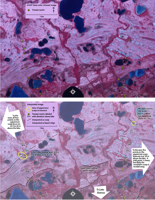
This false-color infrared photo from the Alaska High Altitude Photography program shows the area where our elevation transects show there may be a fault. Data points from two of our fifteen transects are shown on this photo. Accuracy of the alignment between the image and the survey points is approximate, likely introducing an apparent horizontal error of tens of meters.
To the west transect 11 crosses the uppermost beach scarp, with a base 23.8 m above lake level. To the east transect 10 fell short of the highest beach features visible on this air photo, but the highest surveyed point is 31.7 m, well above the scarp to the west. This shows that the uppermost scarp changes in elevation substantially across the few kilometers pictured here. Transects east and west of this point are consistent with this as well, with scarps over 30 m to the east, and scarps between 22.5 and 26 m to the west. One data point to the east that is below 30 m is at the base of a tall scarp, and this scarp cuts out a higher scarp that is traceable to a measurement where it is over 30 m.
A trough that cuts across beach ridges near the center of the image could possibly be related to surface faulting. This furrow post-dates the beach ridges, and does not appear to be a drainage since it is parallel to an established stream-course. Also, it is aligned with other somewhat linear channels in the area. If this feature is a fault, then it is nearly perpendicular to the strike of the Lake Clark Fault, and not on-strike with any major structures mapped in the Lake Iliamna area (Detterman & Reed, 1980).
Map 1: Elevated beaches along Lake Iliamna (outlined in white) and along Kamishak Bay (outlined in blue) overlap major faults (black) in this area. The black rectangle marks an area where our GPS survey appears to show localized deformation (detail in Fig. 2). We found possible evidence of deformation in both these systems of elevated beaches, suggesting these faults may be active. Activity on these faults is relevant to potential development of the Pebble Mine (red). Larger Map