The History and Fate of Fountain Stream
Last modified: 12th August 2019
Related Content
- Life on Ice Journey - main page
- Melting by the Maps - an exploration of change and erosion near Fountain Stream from 1890 to 2011
- Glacier Retreat in Alaska
- Global Warming in Alaska - overview
- Adventures in a Warming Alaska Photos
- Coastal Erosion Photos
- Life on Ice Photos
Fountain Stream is one of the largest rivers draining Malaspina Glacier. The changes in this river over the past 120 years provides an example of how glacial retreat can starve rivers of sediment and lead to erosion downstream, and an example of the complex changes that can result from climate change. In 1891 Fountain Stream was mapped and described by scientists who observed a violent spring dumping sediment into the river and out to the nearby ocean. In a 1948 air photo, Fountain Stream appears similar, but the source of the river has begun to cut back into the glacier. By 1978 large lakes formed upstream (beyond this image crop) capturing sediment. Over the ensuing decades the river has incised into a single large channel, and the coast has retreated nearly a half mile - all driven by erosion resulting from sediment trapping in upstream lakes. In the future, tides rather than meltwater will likely begin to dominate this river.
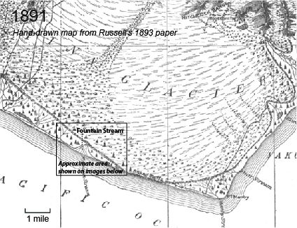
Israel Russell recounts his 1890 and 1891 scientific expeditions to Malaspina Glacier in an extensive paper. From his 1891 visit to Fountain Stream:
“The largest and most remarkable of these springs is the one indicated on the accompanying map as Fountain stream. This comes to the surface through a rudely circular opening, nearly 100 feet in diameter, surrounded in part by ice. Owing to the pressure to which the waters are subjected they boil up violently, and are thrown into the air to the height of 12 to 15 feet, and send jets of spray several feet higher. The waters are brown with sediment, and rush seaward with great rapidity, forming a roaring stream, fully 200 feet broad, which soon divides into many branches, and is spreading a sheet of gravel and sand right and left into the adjacent forest. Where Fountain stream rises, the face of the glacier is steep and covered with huge bowlders, many of which are too large for the waters to move. The finer material has been washed away, however, and a slight recession in the face of the ice bluff has resulted.” - Russell, 1893
In 1891, the stream was providing abundant sediment, including plenty of sand and gravel, This large outpouring of sediment buried surrounding forests, and flowed out to the ocean, likely leading the beach to build outward.
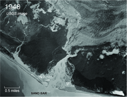
The aerial photo at right shows a scene not dissimilar from what Russell saw in 1891. Again a vigorous stream spreads out in many channels, a “fan”, dumping sediment into the ocean. Beyond the visible beach, the water is likely shallow enough for the river to move sand or gravel all the way to the visible sand bar. The straight-edged forest on the east edge of the photo grow on beach ridge plains - former beaches that became vegetated as new beaches were built beyond them. The sand that supplied this ongoing beach construction came from the sediment-rich stream described by Russell. However, the glacier face had already begun to degrade when this image was taken in 1948. Stream channels have cut back into the ice, lengthening the river. The “rudely circular” spring that Russell describes is no longer apparent. The river also seems larger than what Russell described: at the narrow point at the head of the outwash fan, the river is 500 feet wide, compared to 200 feet in 1891. If this is evidence that the river has grown in volume, then that may be because increased melting and precipitation on the glacier is increasing flow, or it could be because this stream has captured more tributaries as the edge of the glacier melts back from its moraine.
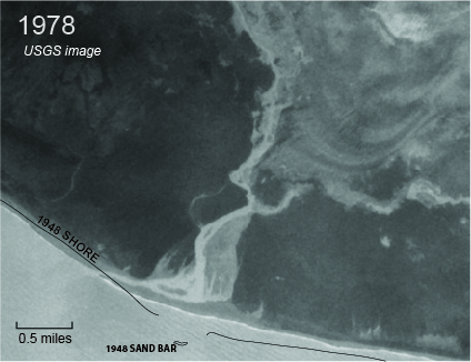
By the point that the photo at right was taken, Fountain Stream drained from much further into the glacier, and it flowed out of a large lake (not shown). The sediment captured by the newly-formed 5-mile long Fountain Lake captured sediment pouring out of the glacier, only allowing silty mud to flow into the lower river and the ocean. As a result, the river became much more erosional, and cut down into the fan that it once formed, becoming confined to a single channel. Similarly less sediment is reaching the beach, and it’s eroding. This is apparent because of the narrow beach east of the river mouth, and by comparison to the 1948 image. Though the beach to the west built out somewhat, the beach to the east has retreted hundreds of feet.
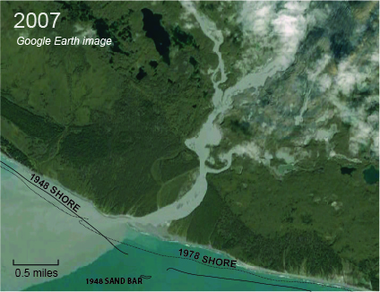
In 2007 when the Google imagery at right was taken, Fountain Stream is larger, carrying a larger portion of the water flowing out of Malaspina Glacier. Growing lakes continue to capture sediment and prevent it from reaching the shore. By this point, new lakes are opening up in the various tributaries feeding out of Malaspina Glacier into Fountain Stream. Even the main channel is becoming irregular as it is undermined by melting ice. The coast is eroding both east and west of the mouth, having lost nearly a half mile since 1948. The sharp transition from river to green vegetation on both shores suggest the river is eroding on both banks. During storm tides (higher than usual tides due to big waves), sediment from the beaches is washed into vegetated former river channels, overrunning soil once protected by a well-nourished barrier beach.
We followed Fountain stream from its source miles upstream of these photos out to the coast in 2011. The once 4-mile long Fountain Lake is filling with sediment at a greatly accelerated rate since 2007. Now only the lower mile of the lake remains open. There was no appreciable drop in elevation from areas where the river was clearly flowing against ice to the ocean, so storm surges and perhaps normal high tides are reaching the glacier. Melt-related depressions along the edge of the river are filled with large sand bars - sand that might otherwise have reached the beach to provide resistance to wave erosion. On the eroding beach, a band of dead trees lines the shore, and soft forest soil can be seen protruding from the storm battered beach face. Boulders on these beaches are small and nearly spherical - evidence that they are being moved and abraded away by the surf.
If current trends continue, coastal erosion will accelerate as the remaining coarse sediment on the beach is degraded. It’s possible new sediment would start flowing in the river again if Fountain Lake filled completely, but that is still a ways off and new lakes are opening up even right at sea level. Lakes so close to the shore will capture an even larger portion of the glacier’s sediment. Tidal flux into these lakes will help ream sediment out of the stream, carry warm ocean water to the ice, and help transport icebergs from the glacier to the ocean. Eventually, this site, like Sitkagi Lagoon and Malaspina Lake, will become dominated by interaction with the ocean. Some or all of these gaps in the moraine armor of Malaspina Glacier will provide access to a new bay where Malaspina now sits.
Created: Jan. 19, 2018