Introduction
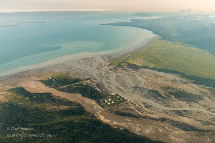
The Drift River Oil Terminal is a short-term oil storage facility on Cook Inlet that is controversial due to its vulnerability to volcanic mudflows from Redoubt Volcano. The terminal is located directly under Mt. Redoubt in the Drift River valley, on the western shore of Cook Inlet. It receives oil via underwater pipleines from oil extraction platforms in western Cook Inlet, stores the oil temporarily in a tank farm, and then loads into oil tankers.
Also known as the “Drift River Terminal Facility” or “Drift River Marine Terminal”, the terminal is operated by the Cook Inlet Pipe Line company, which is owned by Chevron and Pacific Energy Resources.
Sited in the Drift River’s 100-year floodplain, the tank farm and buried pipeline are exposed to lahars and floods from Mt. Redoubt, which is one of Alaska’s most active volcanoes. The facility has been partly inundated at least twice, during Mt. Redoubt’s 2009 eruption and its 1989-1990 eruption. If the facility was destroyed without adequate warning, it could potentially cause an oil spill of up to 18.5 million gallons - comparable in size to the Exxon Valdez spill.
Structure and Function
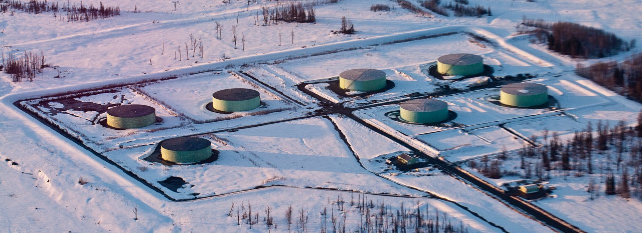
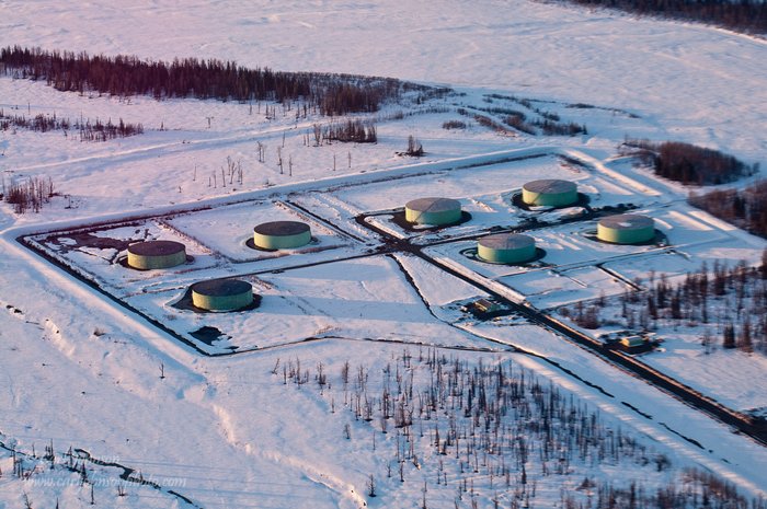
Cook Inlet’s oil platforms have little or no on-board oil storage. The rate of oil pumping is too slow to make it economical for empty tankers to be stationed directly at the platforms, and Cook Inlet’s storms would make it physically dangerous. To resolve this, the oil platforms deliver their crude oil to shore via underwater pipelines. In western Cook Inlet, these pipelines feed to the Drift River oil storage facility and terminal. There, the oil is stored until enough accumulates to fill a tanker. The whole Drift River complex consists of two tank farms (the Granite Point tank farm and the Drift River tank farm), a 42-mile long, buried pipeline, and an offshore loading platform which loads oil into tankers in deep water (the Christy Lee platform).
“Oil Under Fire”
READ BLOG POST
_
…So the facility was sited near the mouth of the Drift River to take advantage of the steep delta left by thousands of years of volcanic mud flows (lahars) from nearby Redoubt Volcano. Unfortunately, this placed the facility right where it was vulnerable to these same lahars, and to other volcanic hazards…..
_
The siting of the terminal in a lahar floodplain is not coincidence. The Drift River delta is a steep-fronted delta, constructed by lahars and volcanic floods form Mt. Redoubt, which is one of the world’s more active volcanos. It provides a place where large oil tankers can get close to shore while remaining in deep water – rare in the shallow waters of Cook Inlet.
The total oil storage capability of the facility is more than 1 million barrels, or 420 million gallons, the majority of which is at the Drift River tank farm. However, current storage at the Drift River tank farm has been severely curtailed, due to volcanic hazard. Officials have declined to disclose the amount of oil stored at the facility, citing Homeland Security. The pipeline itself contains roughly 120,000 barrels (5 million gallons) of oil.
Volcanic and Lahar Hazard
Mt. Redoubt has melted large sections of the Drift Glacier in its recent eruptions, sending giant mudflows (known as “lahars”) out through the Drift River valley and into Cook Inlet. Lahars are much more destructive than most floods, because they can carry large quantities of rocks and boulders, and because of their massive size. For brief geological moments, Drift River lahars have been the largest rivers in North America.
The Drift River tank farm is currently protected by reinforced earthen berms, which surround the facility. In both 1989-90 and 2009, Redoubt’s lahars overtopped the protective berms. Both lahars also left thick layers of sediment on the floodplain, raising the ground level.
The 1989-1990 lahars flooded buildings and damaged the power generation system, stranding 900,000 barrels of oil at the facility. The 2009 lahars inundated the runway, hangar, and storage areas of the Drift River tank farm. Although the 2009 lahars overtopped the berms and flooded some areas of the terminal, they were prevented from entering the tank farm itself by the deep snow atop the berms. Evidence suggests they came within 0.2 meters of the depth necessary to do so. No oil was spilled.
In response to the 2009 lahars, the protective berms have been raised and reinforced in key areas, and a diversion dike has been built upstream of the terminal, which is intended to break the momentum of a large lahar descending on the facility. The effectiveness of the Drift River tank farm’s current protections and the safety of the pipeline have been disputed by Cook Inletkeeper, a local conservation organization.
Our research
In 2012, Ground Truth Trekking performed a preliminary geological evaluation of the threat to the facility, based on the eruptive history, the facility history, and the geological literature. Our geologists concluded that Mt. Redoubt is capable of generating larger or more erosive lahars than occurred in 1989-90 and 2009, as well as producing glacial outburst floods. A major eruption of Mt. Redoubt could potentially inundate the facility with lahars or floods, produce ashfall that grounds aircraft and limits surface navigation, and perhaps even generate destructive pyroclastic flows. The risk of a extremely large lahars (such as would occur if most of the upper mountain ice melted) is extremely low, since it would occur only in the event of a very major eruption. The risk of limited events (such as a new large lahar in the Drift River valley, a glacial outburst flood, and/or ashall) which damage or temporarily isolate the facility is higher.
Our original report here.
Created: Jan. 19, 2018